
2nd Update:
The National Weather Service issued a flood advisory Sunday for Suffolk County.
At 902 PM EST, Doppler radar indicated heavy rain moving back into areas that received 1 to 2 inches of rain earlier today. – Additional rainfall amounts of 0.3 to 0.6 inches are expected over the area.
This additional rain will result in minor flooding. – Locations that will likely experience flooding include… Levittown, Freeport, Valley Stream, Commack, Long Beach, Huntington Station, Deer Park, Lindenhurst, Plainview, Garden City, Massapequa, Lynbrook, Syosset, Mineola, Huntington, Woodmere, Westbury, Rockaway Beach, Farmingdale and Northport.
A handful of power outages were reported in Huntington and Commack.
A flood watch is in effect until Monday at 1 p.m.
Earlier
—-
Update: All events scheduled for Sunday at the Huntington Holiday Spectacular have been canceled because of the weather.
The town said that Highway Superintendent Andre Sorrentino asks residents to report any downed trees or powerlines.
– Report downed trees, branches and wires blocking roads to Highway at 631-499-0444, at HuntingtonNY.gov/Highway, or [email protected]
– Report power outages or downed wires to PSEG Long Island at 1-800-490-0075, PSEGLINY.com or text OUT to PSEGLI or (773454)
– In the event of a gas emergency, or if you smell gas, National Grid advises you to call 911 or 1-800-490-0045
– Report emergencies to 911
– Report local public safety issues by calling our Public Safety 24/7 Emergency Hotline at 631-351-3234
Officials are urging people to secure holiday decorations and other outdoor objects such as lawn chairs and tools so that they don’t fly loose in the winds, which could gust as high as 60 MPH.
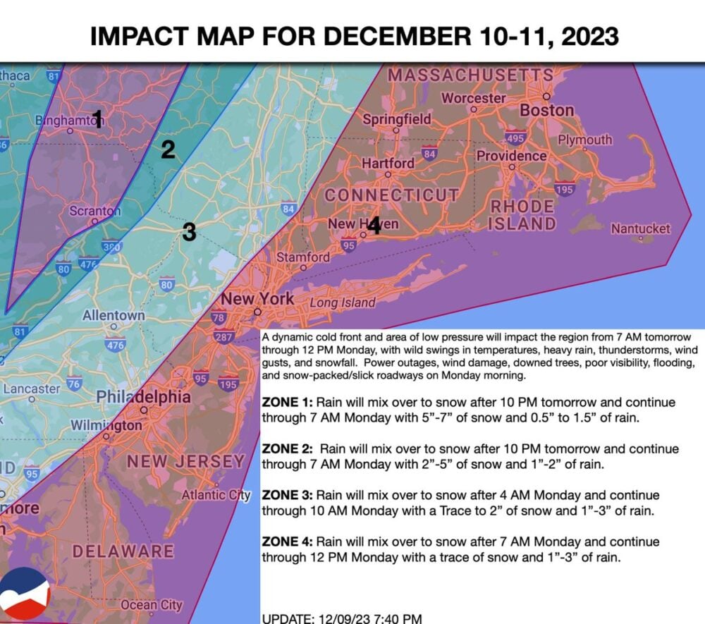
A downpour of two to three inches of rain is possible. Rain is expected to be heaviest overnight, between 2 and 8 a.m. Monday.
PSEG-LI is warning that the rain and wind could bring down trees or branches, adding to driving hazards, and that widespread power outages are possible.
Temperatures are expected to drop Monday.
Residents are encouraged to keep a close eye on weather reports since conditions could change significantly.
“Please be alert for changing weather conditions on Sunday. Strong winds, heavy rain, and flooding all likely Sunday afternoon into 8am Monday, ” News 12 meteorologist Rich Hoffman wrote on Facebook. “Thunderstorms and poor visibility likely as well. WORST is Sunday 7pm to 7am Monday, with that being said still chance of thunderstorms and pockets of heaby rai. before 7pm.”
PSEG-LI Storm Outage Map
News12 meteorologist Rich Hoffman on Facebook